HIKING UKRAINE CARPATHIANS: TOP 5 HIKING TRAILS
2018-11-30 17:14:26
Active Ukraine is back! Last few weeks have been crazy over here, with lots of preparations for the spring season, and exciting trip planning for summer. We are looking forward to host some American, Canadian, British, and French guests in the coming months, and are very excited to show them the best parts of what Ukraine can offer. Meanwhile, for those of you who are still in the 'planning-to-come' phase we have prepared some great tips for hiking Ukraine Carpathians! Enjoy our favorite collection of walking and hiking trails in Carpathians. Read on :)
Ukrainian Carpathian mountains are much less explored than their Slovakian, Polish or even Romanian counterparts. Add to that maps in Cyrillic and barely marked routes, and you are up for a true adventure!
1. Hiking in Ukraine - Borzhava Mountain range
Borzhava mountains are probably the warmest and, weatherwise, most predictable place in Carpathians. Located mere 3 hours drive to the south of Lviv, the range features mountain tops up to 1600 m and is sunny for most parts of the summer. Borzhava mountains are mostly bare, and without forests. So if you are up for some great views and visits to polonyna or highland shepherds, that's your place to go for hiking in Ukraine!
Peaks:
Mt. Stig (1681 m), Mt. Velykyj Verkh (1598 m), and Mt. Magura (1088 m)
How:
Hiking trails start from Volovets. Mountain range can be easily covered in two days, with overnight camping. If you don't have the luxury of time, one day trips are possible as well.
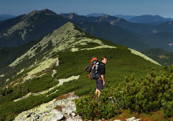
2. Hiking in Ukraine - Chornogora Mountain range
Chornogora range is by-far most well-known and visited area in Carpathians. It's home to Ukraine's highest peaks, and beautiful crystal lakes. The range is easily accessible from Lviv and Ivano-Frankivsk.
Traditionally, hikers choose two starting points as options: either from Mt. Goverla (Ukraine's highest mountain at 2061 m), or from Mt. Pip Ivan, also known as the Black Mountain (2021 m). Trails to Mt. Goverla start at Zaroslyak tourist camp, close to the village of Vorokhta. Mt. Pip Ivan is reached easiest from the village of Dzembronia (formerly known as Berestechko - beware that Google Maps, as well as some older Soviet maps keep this version).
Chornogora is often unpredictable with weather, is extremely windy and likes to shower the unlucky hikers with blasting rain. Keep in mind also, that if you are looking for a really secluded place, Chornogora might not be for you, as it's usually full of hikers in late spring and all summer. Mt. Goverla can get particularly crowded around the Ukraine's Independence Day (August 24th).
Peaks:
Mt. Goverla (2061 m), Mt. Munchel (1998 m), Mt. Gutyn Tomnatyk (2016 m), and Mt. Pip Ivan (2021 m). Highland lakes are Brebeneskul and Nesamovyte.
How:
Chornogora needs careful approach and rigorous planning. You can do day hikes to Pip Ivan (up to 10 hours), or Goverla (6 hours), but for a full hike across the range, you'll need comfortable three days (two days, if you are exceptionally fit and know the route well). Make sure to add it to your list for hiking in Ukraine!
3. Hiking in Ukraine - Marmarosy Alps
Marmarosy Alps are by far the least accessible and most remote part of Carpathian Mountains. Biggest chunk of the range lies within the Carpathian Biosphere Reserve, and due to its proximity to the Romanian border, has been off the hiking in Ukraine maps until recently.
The mountain range has plenty of sunshine, sharp rocky peaks and views, completely unlike the other parts of Ukrainian Carpathians. Getting to hike in the range still requires permission from Ukrainian border guards, and has to be obtained at least a week in advance. Since this process is not really clear for foreigners, Marmasy Apls remain the real wild and unexplored area for true off-the-beaten track lovers!
Peaks:
Mt. Petros (1780 m) and Mt. Pip Ivan Marmarosky (1936 m)
How:
Most hiking trails start from the villages of Bohdan or Dilove, close to the town of Rakhiv, in Transcarpathia region. It's possible to make extensive day trips to the mountain range, but with all the border-paper hassle, it is much more rewarding to take a comfortable two-day hike, possibly combining it into a longer walk to Chornogora mountain range.
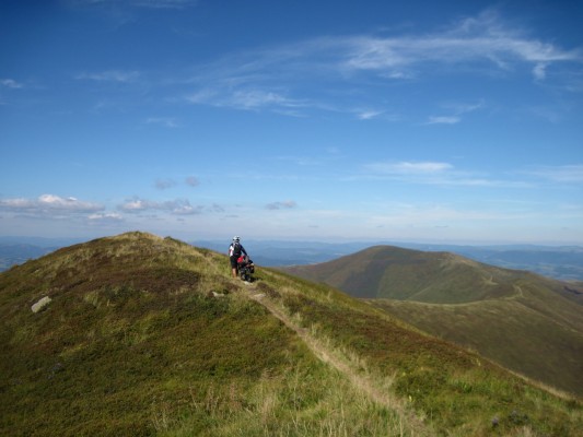
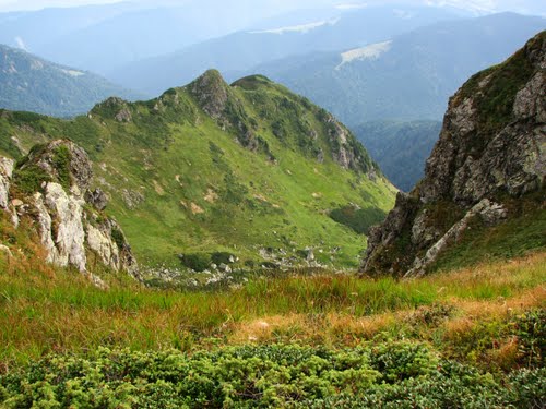
4. Hiking in Ukraine - Gorgany
This mountain range is really loved by experienced Ukrainian hikers. It's not as 'touristy' (as much as unmarked trails can be touristy!) as Chornogora, is much wilder and more challenging for hikes, even though it's generally lower than Chornogora. The mountain range takes its name from the large grey stones that are scattered across its mountain tops, which gives them a very distinct and stunning look! Beware: the stones 'gorgany' can be quite slippery in rain - a common weather forecast in this mountain range.
Join our weekend hiking tour in Gorgany mountain range!
Peaks:
Mt. Grofa (1748 m), Mt. Popadya (1740 m), Mt. Syvulia (1836 m), Mt. Dovbushanka (1754 m) and Mt. Synyak (1665 m)
How:
Easiest starting point to the mountain range is from the well-known ski resort Bukovel or from the town of Yaremche. For those who aren't afraid to go wild on their hiking in Ukraine trip, perfect starting point would be the tiny village of Bystrytsia. Day trips are possible to Mt. Khomyak. However, to experience the full beauty of Gorgany, multi-day treks with overnight camping are the best choice!
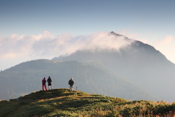
5. Hiking in Ukraine - Svydovets Mountain range
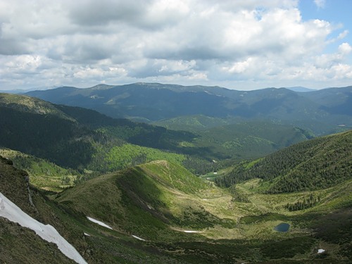
Svydovets mountain range is often called Ukrainian Alps. Similar to Chornogora, it hosts some beautiful highland lakes: crystal clear and freezing cold! Apshynets, Dogyaska, Vorozheske - even their names sound intriguing and a hike up to one of those lakes will definitely leave you with some cold feet, incredible views and amazing photographs!
Join our ultimate-trek-in-Carpathians for a close up look at the top trails for hiking in Ukraine!
Peaks:
Mt. Blyznytsia (1883 m), Mt. Dogyaska (1761 m), Mt. Stig (1704 m).
How:
Mountain range can be approached from the town Yasinya (in the east), or the village Ust-Chorna (in the West). Day hikes are possible, but again - to get truly immersed into the wild nature of Carpathians, we strongly encourage two day hikes with an overnight camping. And surely - what can be better than sleeping under the canopy of Carpathian stars?!
View Carpathian Mountains in Ukraine in a larger map
All photographs in the post are courtesy of Igor Melika, one of our all time favorite nature photographers in Ukraine. Visit his site for more gorgeous photo shots!
Don't forget to email us, if you would like to join one of our day or multi-day treks in Carpathian Mountains!
Where have you been in Carpathian Mountains? What's your favorite mountain range? Comment below and don't forget to spread the news on Facebook and Twitter!

Travel with us
Join thousands of travelers, who explored Ukraine with our adventure, cultural or heritage tours since 2011.Trusted by National Geographic, BBCW, Wild Frontiers and others.
Ask us anything